Aerial surveillance has changed dramatically over the last two decades. What was once the domain of military aircraft and satellites is now supported by a wide range of technologies capable of monitoring large areas quickly, accurately and at a fraction of the cost.
Today, aerial surveillance systems are used for far more than military operations. They help secure national borders, protect critical infrastructure, support environmental monitoring and assist emergency response teams. By providing a real-time view of events on the ground, these technologies allow organizations to gather valuable information while reducing the need for personnel to operate in potentially dangerous environments.
How Aerial Surveillance Is Used in Modern Warfare
Recent conflicts in Ukraine and the Middle East have highlighted just how important aerial surveillance has become in modern military operations.
In Ukraine, drones are used around the clock to observe the battlefield, track troop movements, identify supply routes and locate military assets. In many cases, commanders rely on real-time aerial intelligence to plan operations and respond quickly to changing conditions on the ground.
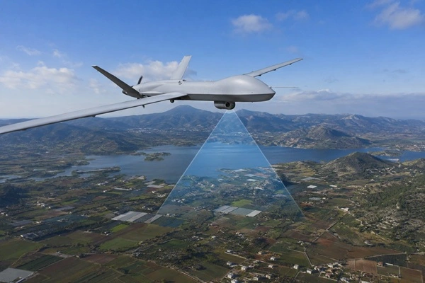
One of the most remarkable developments has been the ability of modern drones to operate far from the front lines. Long-range unmanned aerial vehicles (UAVs) can monitor strategic targets located dozens or even hundreds of kilometers away, transmitting live video and precise coordinates to military units in real time.
Aerial surveillance is no longer limited to simply observing enemy activity. Modern systems can automatically detect vehicles, track movement patterns and process vast amounts of visual data with minimal human intervention. In Ukraine, military forces have also experimented with coordinated groups of drones capable of sharing information and working together during missions.
The Middle East has provided another example of how aerial surveillance has transformed modern warfare. Drones, reconnaissance aircraft and advanced observation systems are routinely used to monitor urban areas, track activity on the ground and collect operational intelligence. In many conflict zones, unmanned aircraft now provide near-continuous surveillance, giving military commanders a constant stream of information.
Another major development is the integration of artificial intelligence into surveillance platforms. Modern software can analyze data collected by cameras, radar systems and thermal sensors, quickly identifying objects, vehicles or unusual activity that might otherwise go unnoticed. This significantly reduces response times and improves situational awareness.
Modern warfare has shown that battlefield superiority depends not only on firepower, but also on the ability to gather information, understand the operational environment and react faster than the opponent. In many situations, drones, sensors and automated surveillance systems have become just as important as traditional military assets.
What Is Aerial Surveillance?
Aerial surveillance refers to the observation, monitoring and collection of information from platforms operating above the ground. By providing a bird’s-eye view of an area, these systems can detect activity, track movement and gather intelligence over large distances.
A wide variety of platforms can be used for aerial surveillance, including:
- Manned aircraft
- Unmanned aerial vehicles (UAVs)
- Helicopters
- Tethered aerostats
- Satellites
- High-altitude, long-endurance aircraft
The primary goal is to gain situational awareness of a specific area, allowing operators to identify unusual activity, monitor ongoing events and respond quickly to potential threats.
Why an Aerial Perspective Matters
Ground-based observation has obvious limitations. Buildings, vegetation, rugged terrain and sheer distance can make it difficult to detect people, vehicles or suspicious activity.
An aerial platform, on the other hand, can cover large areas from a single vantage point while providing real-time imagery and valuable intelligence. This broader perspective allows operators to spot patterns and developments that would be difficult to recognize from the ground.
As a result, aerial surveillance has become an essential tool for:
- Military forces
- Law enforcement agencies
- Coast guards
- Emergency response organizations
- Critical infrastructure operators
- Energy companies
Surveillance Drones
Among all modern surveillance technologies, drones have arguably had the greatest impact on the industry.
Over the past decade, unmanned aerial vehicles (UAVs) have become increasingly popular thanks to their flexibility, relatively low operating costs and ability to access areas that may be difficult or dangerous for manned aircraft.
Modern surveillance drones can carry a wide range of sensors, including:
- High-definition cameras
- Thermal imaging systems
- Night-vision equipment
- Multispectral cameras
- Environmental monitoring sensors
Many platforms can stream live video over radio or satellite links, allowing operators to monitor events in real time from considerable distances.
The most advanced systems are capable of remaining airborne for more than 24 hours, making them ideal for long-duration surveillance missions where continuous observation is required.
Fiber-Optic Drones: One of the Most Significant Innovations in Modern Warfare
Among the technologies that have emerged from recent conflicts, fiber-optic drones have attracted considerable attention. Unlike conventional drones that rely on radio communications, these systems remain physically connected to the operator through an ultra-thin fiber-optic cable that is deployed during flight.
At first glance, the concept may seem outdated compared to wireless drone technology. In practice, however, it has proven highly effective on today’s battlefield.
The widespread use of electronic warfare systems, particularly in Ukraine, has made it increasingly difficult for traditional radio-controlled drones to operate reliably. Electronic jammers can interfere with or completely disrupt radio signals, causing drones to lose communication with their operators.
Fiber-optic drones solve this problem by transmitting commands, video feeds and telemetry data directly through the cable rather than over radio frequencies. Because no wireless communication link is required, these drones are largely immune to conventional jamming techniques.
This provides a major tactical advantage, especially in contested environments where both sides deploy sophisticated electronic warfare systems.
Another important benefit is the quality and reliability of the connection. Fiber-optic links can deliver stable, high-quality video with minimal interference, allowing operators to maintain clear situational awareness throughout the mission.
Since these drones do not depend on radio transmissions for communication, they are also more difficult to detect using systems designed to identify and track radio-frequency emissions. This can help reduce the risk of revealing the operator’s position.
Like any technology, fiber-optic drones have limitations. Their operational range depends on the length of the cable carried onboard, and the fiber can become tangled in vegetation, power lines or urban obstacles. These factors can restrict their use in certain environments.
Despite these challenges, fiber-optic drones are becoming increasingly important for reconnaissance, target acquisition and close-range surveillance missions. Many military analysts consider them one of the most influential battlefield innovations of recent years, as they have significantly reduced the effectiveness of electronic jamming systems that were once among the most reliable defenses against unmanned aircraft.
High-Resolution Optical Cameras
Despite the rapid evolution of surveillance technology, optical cameras remain the primary sensor used in most aerial surveillance missions.
Modern imaging systems are capable of capturing highly detailed images from significant distances, allowing operators to observe activity on the ground without approaching the target area. Advances in optics, image processing and stabilization have dramatically improved the effectiveness of these systems over the last decade.
Common features found in modern aerial surveillance cameras include:
- High-power optical zoom
- Electronic image stabilization
- Automatic target tracking
- 4K and 8K video recording
- Advanced digital image processing
These capabilities allow operators to follow moving vehicles, monitor critical infrastructure and observe suspicious activity while maintaining a safe stand-off distance.
Thermal Imaging and Night Vision Systems
Conventional cameras depend on visible light and may become less effective at night or in poor weather conditions.
To overcome these limitations, many surveillance platforms are equipped with thermal imaging systems. Rather than capturing visible light, thermal cameras detect heat signatures emitted by people, vehicles, buildings and equipment.
This allows operators to identify targets even in complete darkness or when visibility is limited.
Thermal imaging is widely used for:
- Search and rescue operations
- Border security
- Maritime surveillance
- Wildfire detection and monitoring
- Industrial inspections
In many situations, thermal sensors can reveal activity that would be impossible to detect using conventional cameras alone.
Airborne Radar Systems
Radar technology remains one of the most important components of modern aerial surveillance.
Unlike optical sensors, radar systems can operate effectively in rain, fog, cloud cover and other conditions that may limit visibility. This makes them particularly valuable for long-range monitoring and all-weather operations.
Airborne radar is commonly used to:
- Detect aircraft
- Track vessels at sea
- Monitor air traffic
- Survey large land areas
Modern radar systems are capable of detecting extremely small movements and tracking multiple targets simultaneously. Some advanced platforms can even distinguish between different types of vehicles or identify unusual activity over vast areas.
For this reason, radar continues to play a critical role in both military and civilian surveillance operations, often working alongside cameras, thermal sensors and other intelligence-gathering technologies.
Satellite Surveillance
Satellites are among the most advanced tools available for large-scale monitoring and intelligence gathering. Unlike aircraft or drones, they can observe vast regions of the world from orbit, providing valuable information across national borders and remote areas.
Recent developments in satellite technology have dramatically increased both image quality and revisit rates. Modern satellite constellations can capture updated imagery of the same location multiple times per day, offering near real-time visibility in some situations.
Satellite surveillance is widely used for:
- Border monitoring
- Environmental analysis
- Critical infrastructure protection
- Military reconnaissance
- Disaster response and emergency management
The growing availability of high-resolution commercial satellite imagery has also expanded the use of this technology beyond government and military applications, making it an important tool for researchers, businesses and humanitarian organizations.
Artificial Intelligence and Automated Analysis
One of the biggest challenges in modern surveillance is the enormous amount of data generated every day.
A single drone, aircraft or satellite system can collect hours of video footage and thousands of images during a mission. Reviewing all this information manually would require significant time and resources.
To address this challenge, modern surveillance platforms increasingly rely on artificial intelligence and machine learning technologies.
These systems can automatically:
- Identify vehicles
- Detect people
- Flag unusual activity
- Classify objects
- Generate real-time alerts
Rather than analyzing every image manually, operators can focus on the most relevant information, improving efficiency and reducing response times.
As AI technology continues to evolve, automated analysis is becoming one of the most important elements of modern aerial surveillance operations.
Protecting Critical Infrastructure
Aerial surveillance also plays a vital role in protecting critical infrastructure.
Many essential facilities cover large areas and can be difficult to monitor effectively using only ground-based security measures. Aircraft, drones and satellite systems provide an additional layer of visibility that helps operators quickly identify potential threats or operational issues.
Common applications include monitoring:
- Airports
- Seaports
- Oil pipelines
- Gas pipelines
- Power plants
- Railway networks
These systems can help detect damage, unauthorized access, suspicious activity or technical anomalies before they develop into more serious problems.
Border Security and Area Monitoring
Many countries rely on aerial surveillance technologies to strengthen border security and improve situational awareness across remote regions.
Long-range drones can patrol areas that would be difficult, expensive or dangerous to monitor from the ground. Thermal imaging systems can detect movement at night, while radar and satellite platforms provide continuous coverage over large territories.
Beyond security applications, these technologies are also used during search and rescue operations, helping authorities locate missing persons and coordinate emergency responses more efficiently.
The Future of Aerial Surveillance
The future of aerial surveillance will likely be defined by greater integration between drones, satellites, radar systems and artificial intelligence.
Future platforms are expected to become increasingly autonomous, capable of operating for extended periods with minimal human intervention. Advances in sensor technology will further improve the ability to detect, classify and track objects across large areas.
At the same time, engineers are working to develop more efficient propulsion systems, including electric and hydrogen-powered aircraft designed to reduce operating costs and environmental impact.
The goal is clear: extend operational endurance, improve data collection capabilities and provide faster, more accurate intelligence while reducing the resources required to maintain surveillance operations.
Conclusion
Aerial surveillance technologies have become an essential component of modern security, intelligence gathering and infrastructure protection.
From drones and radar systems to thermal imaging cameras, satellites and AI-powered analytics, these technologies provide organizations with unprecedented visibility over the areas they need to monitor.
As artificial intelligence, sensor capabilities and aircraft technology continue to advance, aerial surveillance will become even more effective, offering levels of awareness and operational insight that would have been difficult to imagine just a few years ago.